By Amy Wolf
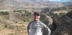
Vanderbilt archaeologist and historical anthropologist Steve Wernke and Data Science Institute postdoctoral research fellow Giles Morrow are exploring the remains of a 16th-century church high in the Andes Mountains of Peru. They’ve brought decades of data and research materials to the site and moved an ancient relic found in a nearby town to its original spot in the church. And they’ve done all this while giving Vanderbilt students a front-row seat.
Wernke’s and Morrow’s work, however, isn’t part of an elaborate study abroad trip. This breakthrough archaeological research is being conducted using virtual reality, artificial intelligence and geospatial technologies.
“We’re undergoing a geospatial information revolution in archaeology. It would be impossible to do this using traditional field-based methods,” said Wernke, associate professor of anthropology and director of the Vanderbilt Initiative for Interdisciplinary Geospatial Research.
Wernke, Morrow and a network of collaborators are using advanced geospatial modeling and analysis across a range of scales in search of better understandings of the experience of places and their emplacement in the landscapes of the Andean past.
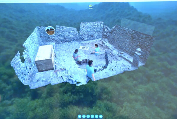
They are using advanced photogrammetric techniques to produce full scale “digital twins” of buildings, excavation areas and settlements, which can then be re-experienced through immersive virtual reality. At much larger scales, they are systematically surveying high-resolution imagery over vast areas to gain a better understanding of the true distribution of archaeological sites in the Andes.
A multi-institutional grant from the National Science Foundation’s Computer and Information Science Engineering division is helping fund this work, which is also highlighted in two Ancient Americas National Geographic specials that recently aired in the U.S. and are scheduled to air throughout Latin America.
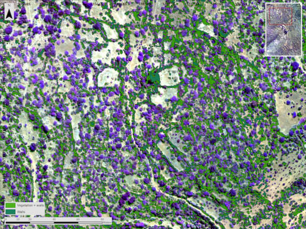
Multiple survey teams from Vanderbilt, the University of Pittsburgh, Brown University and several institutions in Peru, surveyed satellite images and historical photos covering 185,000 square kilometers in the region. They discovered about 40,000 archaeological sites throughout Peru, northern Chile and northern Bolivia.
The data are compiled on the Geospatial Platform for Andean Culture, History and Archaeology, or GeoPACHA, the largest archaeological imagery survey in the Americas.
VIRTUAL REALITY
A key to bringing to life virtual reality excavations is layering the new on the old. Wernke and his team processed photos from a 1930s aerial expedition to Peru into detailed 3D models and map-correct images.
The result is a form of time travel—enabling observation of sites that have been radically altered or destroyed in the intervening decades. In VR, these models can also coexist with their modern counterparts derived from drone mapping missions.
“One reimagined archaeological site may actually be 20 or 30 different models of this same space during different phases of excavation over years or even decades of time,” Morrow said.
The process creates incredibly realistic results.
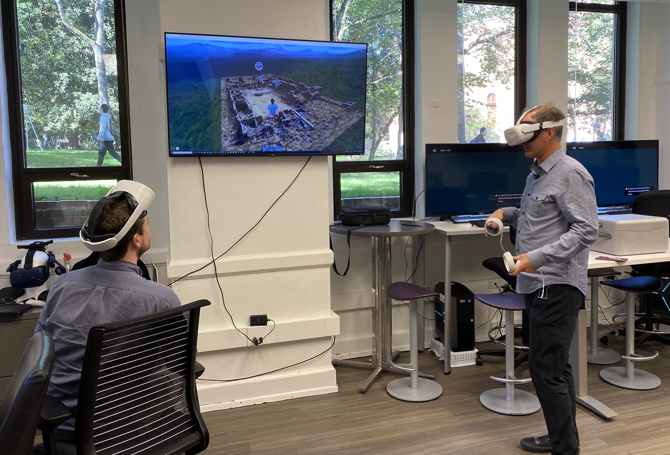
“I’ve actually never physically been to this site, but I’ve been working in it virtually for quite a while,” Morrow said. “I gave a lecture recently where 30 people arrived in the site in virtual reality. I was able to bring in objects and talk about them in an in-depth way, which really brings students into this research in a way that’s impossible otherwise.”
ARTIFICIAL INTELLIGENCE
At large scales, the challenge in having massive amounts of data is creating a strategy that makes the data useful. That’s where artificial intelligence and cooperation between Vanderbilt’s Spatial Analysis Research Lab and experts in computer science come in.
Wernke’s team is collaborating with researchers at Purdue University and Brown University to develop an AI-assisted imagery survey and classification pipeline. They were recently awarded a multi-institutional collaborative NSF grant to develop this human-AI teaming approach.
“What this NSF grant will also enable us to do is utilize artificial intelligence to categorize sites and actually pull out more detail from the sites that we’ve identified in the imagery itself,” Wernke said.
The teams will use artificial intelligence for site detection to extend the geographic survey even further, and to aid in the classification of sites by type and time period.
“In the past, archaeologists have had only ‘pinholes’ to look through from our field surveys, leaving to the imagination what the wider distribution of archaeological sites might be like. These AI-assisted techniques promise to provide that much broader perspective,” Wernke said.
Vanderbilt anthropology doctoral candidates Gabriela Ore Menendez and James Zimmer-Dauphinee work extensively on the artificial intelligence component of this research.
“The first step in artificial intelligence is to train the computer to recognize specific elements and classify them,” Oré Menéndez said. “We’re using GeoPACHA as training data for the AI neural network to enable it to eventually go out and survey even larger areas autonomously.”
She is working with the software to identify parts of the agricultural landscape found in satellite and drone photos to understand why ancient peoples moved from their ancestral lands.
BIOMEDICAL ENGINEERING HELPS ARCHAEOLOGY
Working in collaboration with Yuankai Huo, assistant professor of computer science and computer engineering, Zimmer-Dauphinee and Wernke are developing a Convolutional Neural Network (CNN) to autonomously detect abandoned architecture in satellite images.
This collaboration stems from unexpected commonalities in the problems of biomedical imaging and virtual archaeological survey.
“Just as tumors are made of the same materials as other tissues in the body, archaeological sites are made from the same materials as the surrounding landscape. The problem for both fields identifying features from a common background signal,” Zimmer-Dauphinee said.
Wernke believes the ultimate goal is to create a new understanding of people’s experiences and environments across the long sweep of the human story in the Andes. This could give greater insight into past urban growth and thus possibly aid future urbanization.
“The fundamental reason why I do this kind of research is to co-produce with my hosts understandings of the cultural legacies that the ancient peoples of the Andes have endowed on their descendants, and to bear witness to the challenges and injustices that they endured through European invasion and colonization, even as they persevered and maintained a measure of self-determination to the present,” Wernke said.
- See the latest happenings in Wernke’s Spatial Analysis Research Lab
- Look at the latest discoveries from GeoPACHA, the Geospatial Platform for Andean Culture, History and Archaeology
- Learn more about the Vanderbilt Initiative for Interdisciplinary Geospatial Research
- Learn more about archaeology and anthropology in the College of Arts and Science