


In April 2021, Keryn Gedan and her husband rented a 24-foot white RV camper nicknamed “Rose Nylund” and drove from their home in Washington, D.C., to Huntington Beach State Park on the coast of South Carolina.
They parked at a beachside campsite and took in the view: emerald green salt marshes to the west, rolling sandy dunes just ahead, shore birds flying above. It was spring break and Gedan, an assistant professor of biology at George Washington University who endured two semesters of difficult pandemic-style teaching, had finally left her work behind. Or so she thought.
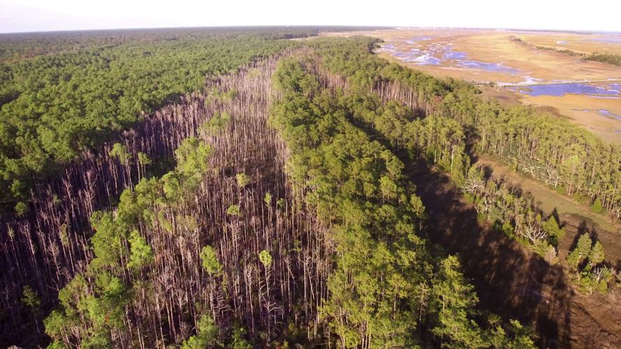
During a short walk to the park's nature center, she came across a stand of dead trees.
“Of course, I had to march over, climb over the debris ... and immediately check out which species were dying here,” Gedan said. Lingering snags of loblolly pine trees, longleaf pine trees, many of great size, some completely toppled — she counted more than 100. She snapped photos on her phone. Bare branches reached toward a cloudless, lapis blue sky.
Gedan didn't need to ask the park ranger what had killed these trees. She knew the mark of sea level rise all too well.
Most visitors don't.
“We get so many questions about that site and people misunderstand what they are. They think it's from a beetle or from wind," said Mike Walker, an interpretative park ranger whose office is just a few hundred yards away. "It's sea level rise interacting with king tides." Such high, seasonal tides now bring floodwaters to parts of this forest and the adjacent road about 15 times a year.
Walker started working at the park in 1991. The road never flooded then. He's sure of it.
On that sunny April day in 2021, Gedan opened the app Survey123 and toggled to the form for Ghosts of the Coast. She uploaded the photos and answered a few questions, including one that asked: "How long have you been visiting this location?" Gedan marked, "This is my first time."
A small golden dot would soon appear on the Ghosts of the Coast map, joining a half-dozen other dots marking ghost forests that people, scientists and citizen scientists alike, have noticed forming along the coast of South Carolina.
See something, say something, it's now as easy as that when it comes to dead trees on the coast.
'So visible, it's an opportunity'
Anyone with a cellphone can submit an observation. Since 2021, the project has been in a pilot phase.
"It's now ready for broad distribution," said Gedan, who actually came up with the idea for a citizen science project and launched Ghosts of the Coast with help from Sarah Noyes, one of her former students.

The term ghost forest is centuries old. Though not scientific, it has been useful for scientists to talk with landowners about an old phenomena, trees dying in large stands, within the context of a new phenomena, human-caused sea level rise along the Atlantic Ocean.
Flooding has always brought salt to upland forests. And pine trees can tolerate small amounts of salt in the soil. But the sheer number of times salt is penetrating to the root systems is becoming intolerable.
Sea level rise is increasing the frequency of minor flooding from king tides. And climate-charged hurricane seasons are increasing the frequency of major flooding from storm surges. Salt can seep and resurface through the groundwater. The number of climate factors bringing more salt to the soil seems to be multiplying.

The intertidal zone is creeping farther inland, replacing vegetation typical of a forest with vegetation more typical of a marsh. Ghost forests are a visible marker of land conversion, places where the upland is becoming a wetland.
Their striking visibility sets them apart. Trunks and stumps linger, though the trees may no longer be alive. Rising tall like gnarled, fraying telephone poles from the low profile of lush salt marshes, the view is undeniably spooky.
It was Gedan's first time visiting that stand of dead coastal trees in South Carolina, but she had spent years studying places just like it in the Chesapeake Bay watershed and North Carolina's Pimlico Sound, home to some of America's largest and, therefore, most studied coastal forests that are succumbing to sea level rise.
“Everywhere you look is a horizon of dead trees," said Gedan about her study sites in the Chesapeake Bay. "The place in Huntington Beach State Park is very small in comparison." She worries that scientists are overlooking these smaller pockets of dying forests.
Filling in the map
According to researchers at Clemson University, there are anecdotes of more and more popping up across South Carolina. But so many are in rural places, hidden from view. Scientists alone can't find them.
"Like, where is this change happening and when?" wondered Gedan. "And I realized that they’re so visible, it’s an opportunity to just ask people."
Recording that observation in Huntington Beach State Park hadn't required much time or effort. In fact, the mobile form she used had been specifically designed for people with no expertise at all. It includes original art of leaf shapes, pine needle patterns and tree silhouettes to help citizen scientists identify which type of forest they're viewing. Noyes, Gedan's former student, did all the art, making use of her double major in art and biology.
“You don’t have to be an expert naturalist to identify that trees are dying,” Gedan said. And because ghost forests are so strikingly visible, the form they designed is a way to crowd-source observations from citizens.
The South Carolina Aquarium has tried something similar but without much luck, at least when it comes to trees. The aquarium has an app-based citizen science project called SeaRise. People can submit their photos and observations from flooding events, including "tree die-off" events. The app's data portal is chock full of flooding photos, but no searchable observations of tree die-off.
'Ghost forest' growth in SC
Gedan’s work had followed her on vacation. Or, perhaps more accurately, she had followed it. The low-lying ribbon of coastline she has journeyed for her family vacation, from the Chesapeake Bay watershed where she studies ghost forest formation, to South Carolina’s Lowcountry makes up about a third of the coastal area where ghost forests are forming in the U.S. thanks to sea level rise.
But even that is a rough estimation.

The longtime focus on North Carolina, Maryland, Virginia and parts of New Jersey as epicenters for ghost forests hasn't been great for those scientists trying to really understand saltwater intrusion — and who it might impact next.
In the Chesapeake Bay region, farmers have already abandoned fields because they are too salty. Timber landowners are already felling trees soon after floods to not lose out on profits. That could happen here sooner than predicted, according to Tom O'Halloran, an associate professor of forestry at Clemson University.
O'Halloran has been studying the creeping spread of drying pine trees near salt marsh edges in and around Georgetown following hurricanes Matthew and Irma in 2016 and 2017.
It wasn't until after Hurricane Dorian in 2019, when storm surges broke through some natural barriers in the landscapes, that they started seeing change. His research team has been using drones and soil monitoring to track the extent of change. In 2023, O'Halloran expects to see more death and dying.
Last year, Hurricane Ian passed just south of the Clemson study site and produced the biggest storm surge since Hurricane Hugo.
"Compared to other states ... it may be that this ghost forest phenomena is happening a little slower here. It may be more visible in the Chesapeake, it may be more visible in North Carolina because of the different coastal topography (in South Carolina)," O'Halloran said. "But, at least here in Georgetown ... it's really picked up just in the last few years.”

A "ghost forest" flooded again on Nov. 24, 2022, along North Beach Read in South Carolina's Huntington Beach State Park. The site is part of a multi-state citizen science project mapping areas where sea level rise is causing large-scale tree mortality. John Belanger/Provided
O'Halloran paused.
“Ya know, this is a great time to to write this kind of article," he said. O'Halloran emphasized just how much he and his Clemson colleagues have been struck by how many ghost forest stands they now see around Clemson's Baruch Institute of Coastal Ecology and Forest Science in Georgetown.
On Jan. 22, the road leading from Huntington Beach State Park's nature center to the North Beach parking lot flooded. Again. Walker, the park ranger, is fed up.
“It’s happening with frightening regularity ... so I'm actually working on making an interpretive sign right now," Walker said bluntly. He wants to put all the questioning and preconceived notions to bed.
It's not those other things; it's climate change. That's essentially what the sign will say.
Once the sign goes up this spring, perhaps by the time families from across the East Coast pull up in their campers for spring break, Walker won't be tasked with constantly explaining why the trees are dying. He can focus on helping people understand what can be done about it.
The easiest way to help, at least for now, is to take a picture and send it to a scientist.


