
Sawatch Mountain Range
Running from north of Leadville to southwest of Salida, the Sawatch Range consists of 15 peaks of 14,000 feet or more including Mt. Elbert, at 14,440 feet the highest in Colorado and second highest in the lower 48 states. The Collegiate Peaks, named after five famous universities, are a part of the range.

Sangre de Cristo Mountain Range
Running south from Poncha Springs to Santa Fe, New Mexico. This portion of the Rocky Mountains is the southernmost subrange. A wilderness area and multiple 14,000-foot peaks are located here, as well as the Great Sand Dunes National Park and Preserve.

Mosquito Mountain Range
Alpine tundra, adjoining forests and rare plant species are found in this area northeast of Buena Vista. The Mosquito Range features five fourteeers: Lincoln, Bross, Democrat, Cameron and Sherman. It is also home to the highest vehicle route in the country, Mosquito Pass, cresting at 13,185 feet.

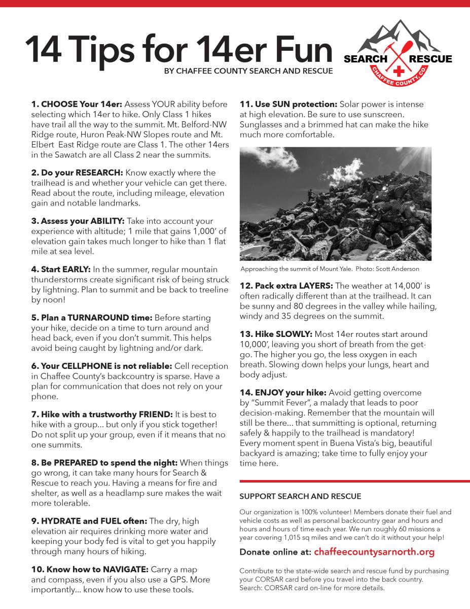
Hiking and climbing at 14,000 feet is no joke
DO YOUR RESEARCH
Most of the fourteener routes involve Class 2 scrambling or climbing. Only a few fourteeners have hiking routes to the summit. Determine your route based on your ability and others in your group. Roads to the trailhead can oftentimes be a journey on their own, so make sure your vehicle can safely travel to the trailhead. Check the weather forecast ahead of time and plan appropriately.
MAKE A PLAN
Summertime in Colorado’s high country means afternoon thunderstorms, so check the weather beforehand, plan an early start, have a group turnaround time, and be back below tree line by noon. Cell service is spotty to non-existent in the backcountry, so plan for alternative communications. Remember, summiting is optional but returning to the trailhead happy and safe is mandatory!
PACK THE RIGHT GEAR
The old saying goes that if you don’t like the weather in Colorado, then wait five minutes. The weather at 14,000 feet can be radically different than at the trailhead, so make sure your pack includes extra layers, plenty of water, food and the 10 Essentials to get you through an unplanned night.

The Adventure By Nature Pledge is an outreach and education project supporting outdoor recreation, economic and visitor growth in Chaffee County by encouraging responsible recreation, stewardship principles and best practices for visitors and residents recreating in the outdoors.
We believe that stewardship of the environment is everyone’s responsibility. Please help us protect and preserve our home so future generations can enjoy it just as you have.


Salida Mountain Trails
In Salida, mountain bikers have a wide variety of trails to ride right from town on Arkansas Hills or Methodist Mountain trails. Among a multitude of choices outside of town, the famed Monarch Crest Trail starts at the top of Monarch Pass and connections to the Colorado Trail are just off U.S. 50 between Maysville and Garfield.
Chaffee County
Search and Rescue – North
P.O. Box 1671
Buena Vista, CO 81211
ChaffeeCountySARnorth.org

Chaffee County
Search and Rescue – South
P.O. Box 313
Poncha Springs, CO 81242
ChaffeeSARsouth.org

National Trail Systems

Colorado Trail
The Colorado Trail stretches 486 miles from Denver to Durango. Trail users experience six wilderness areas and eight mountain ranges topping out at 13,271 feet, just below Coney Summit at 13,334 feet. The average elevation is over 10,000 feet and it rises and falls dramatically. Users traveling from Denver to Durango climb 89,354 feet. The Chaffee County section is popular with day and overnight hikers alike.

Continental Divide Trail
The Continental Divide separates the rivers and streams that flow eastward into the Atlantic Ocean from those that flow westward to the Pacific.
The portion of the Continental Divide in the United States is about 3,000 miles long – from Glacier National Park in Montana, south through the Rocky Mountains, to the Mexico border in southwest New Mexico.
The Sawatch Range segment in Chaffee County follows the flanks of Colorado’s highest peaks, with nice stretches above timberline in portions of the Holy Cross, Mount Massive, and Collegiate Peaks wilderness areas.

American Discovery Trail
The Colorado Trail stretches 486 miles from Denver to Durango. Trail users experience six wilderness areas and eight mountain ranges topping out at 13,271 feet, just below Coney Summit at 13,334 feet. The average elevation is over 10,000 feet and it rises and falls dramatically. Users traveling from Denver to Durango climb 89,354 feet. The Chaffee County section is popular with day and overnight hikers alike.

 140 West 1st Street
 Salida


© Chaffee County Visitors Bureau | All Rights Reserved
Site developed by ![]() Agency Tourism Marketing
Agency Tourism Marketing