From the highest point in the Coast Range to the broad, sandy beaches of the Central Coast, one of Oregon’s newest byways follows the Alsea River on a delightfully meandering 72-mile/116-kilometer tour.
It’s always tempting to make a beeline for Oregon’s magnificent coast, but this byway encourages you to take it slow — not only to navigate the often narrow, twisting road but to discover the many attractions hiding just beyond the highway.
Willamette Valley to Marys Peak
The byway begins near Interstate 5 and Tangent, where farmers established the state’s first grange. The agriculturally abundant Willamette Valley produces most of the nation’s turf grass seed, along with hazelnuts, berries, mint and many other crops.
Oregon State University, in neighboring Corvallis, has long been a leader in farming and forestry research. The lively college town hosts a roster of arts, music, lectures and sporting events throughout the year. Beyond campus, an impressive network of multiuse trails makes it easy to enjoy the city’s riverside parks, natural areas and renowned Willamette Valley wineries.
A few miles south, the William L. Finley National Wildlife Refuge preserves vast camas fields, a harvest staple of the native Kalapuya people. Twelve miles/19.3 kilometers of trails meander through diverse habitats, with interpretive signs about area wildlife and culture. The Philomath Museum shares more of Benton County’s history in the 1867 Philomath College building, one of two colleges that operated here in the late 1800s.
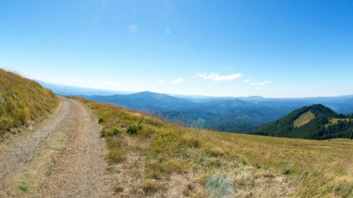
West of Philomath, the byway turns southwest onto OR-34. In 10 miles/ 16 kilometers is the first of two unique spurs on this byway: Marys Peak Road — built by the Civilian Conservation Corps — ascends past waterfalls and stonework lookouts toward Marys Peak. At 4,097 feet/1,249 meters, it’s the highest point in the Oregon Coast Range. In late spring and summer, wildflowers dapple the summit meadows. Hiking trails stitch through this designated Scenic Botanical Special Interest Area, with views that encompass a string of Cascade peaks and the distant Pacific.
Alsea River Valley
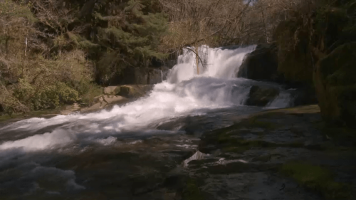
Returning to OR-34, the byway follows the Alsea River through its verdant valley and little burgs like Alsea, settled by pioneers traveling the Applegate Trail. The second spur, South Fork Road, leads 10 miles/16 kilometers to the Alsea Falls Recreational Site, with a campground and trails along the lovely stair-step falls. Nearby, mountain bikers enjoy a growing network of single-track at the Fall Creek State Recreation Area, named by the Bureau of Land Management as one of their top 20 mountain-bike destinations in the nation.
Back on the byway, the century-old Hayden Covered Bridge adds bucolic charm 2 miles/3.2 kilometers west of Alsea, where the river begins to coil tighter on its westward journey. Plenty of waysides like the Missouri Bend Recreation Site provide ample opportunities to picnic, camp, fish or float the river. The state’s salmon fishery is the focus at the Oregon Hatchery Research Center, a few miles up Fall Creek Road. Exhibits (and tours, by appointment) explain how scientists are studying hatchery salmon and steelhead, with the goal of improving rearing practices and protecting wild fish populations.
Just beyond the communities of Tidewater and Little Albany, Risley Creek Road (FR-3446) leads into the Drift Creek Wilderness, home to old-growth Sitka spruce, Western hemlock and Douglas fir. The Siuslaw National Forest district ranger office in Waldport has maps and information.
Waldport
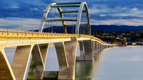
The Alsea River slows and widens into Alsea Bay as it approaches coastal Waldport. Mill Street leads north to the Port of Alsea, where boaters can launch a kayak or rent a small runabout to explore the expansive bay. The 10-mile/16-kilometer Alsea River Water Trail winds through Alsea Bay, Drift Creek and Lint Slough — an estuary thriving with fish, waterbirds and seals. The sandy flats under Waldport’s Alsea Bridge are a top spot for crabbing and clamming. At the foot of the bridge, the Alsea Bay Historic Interpretive Center offers crabbing and clamming demonstrations, and exhibits about the artistic bridges of the Oregon Coast.
The byway concludes here, at the junction of US-101, the Pacific Coast Scenic Byway. Heading south, harbor seals haul out across from the Keady Wayside, where the Alsea River swirls into the Pacific. To the north, a spine of rocky islands and tide pools at Seal Rock State Recreation Site showcases the sublime beauty of the Coast.
Want more details?
Order a free Oregon Scenic Byways guide online.